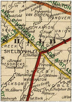
Shelby County, Indiana
Neighboring Counties
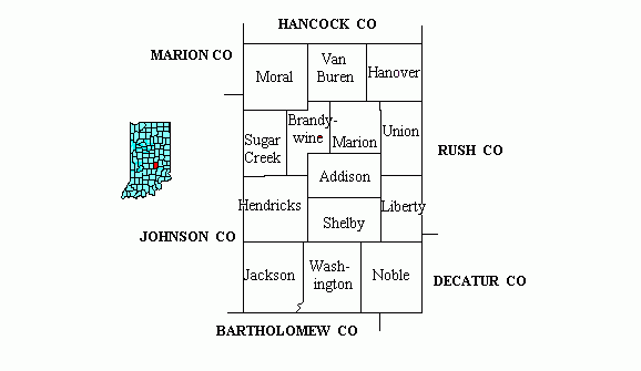
Neighbors: Hancock Co Rush Co Decatur Co Bartholomew Co Johnson Co Marion Co
Shelby Co Twps: Moral VanBuren Hanover Sugar Creek Brandywine Marion Union
Hendricks Shelby Addison Liberty Jackson Washington Noble
~ ~ ~ ~ ~ ~ ~
Federal Townships, Ranges, and Sections
(each of the sections below are linked)
Neighboring Counties
Neighbors: Hancock Co Rush Co Decatur Co Bartholomew Co Johnson Co Marion Co
Shelby Co Twps: Moral VanBuren Hanover Sugar Creek Brandywine Marion Union
Hendricks Shelby Addison Liberty Jackson Washington Noble
~ ~ ~ ~ ~ ~ ~
Federal Townships, Ranges, and Sections
(each of the sections below are linked)
|
T14N R5E |
T14N R6E |
T14N R7E |
T14N R8E |
|
T13N R5E |
T13N R6E |
T13N R7E |
T13N R8E |
|
T12N R5E |
T12N R6E |
T12N R7E |
T12N R8E |
|
T11N R5E |
T11N R6E |
T11N R7E |
T11N R8E |
Federal TOWNSHIP lines run east to west; in Indiana, the higher the number, the further north.
Township 14 North [T14N], orig Hanover Twp, incl current townships Moral, Van Buren & Hanover.
Township 13 North [T13N], originally Union Twp, incl current townships of Sugar Creek, Brandywine, northern Addison, Marion and Union.
Township 12 North [T12N], originally Hendricks Twp, incl current townships of Hendricks, southern Addison, Shelby and Liberty.
Towhship 11 North [T11N], orig Noble Twp, incl current townships of Jackson, Washington & Noble.
Federal RANGE lines run north to south; in eastern Indiana, the higher the number, the further east.
Range 5 East [R5E] begins in Johnson Co and ends about 1/3 of the way through Moral Twps, heading east.
Range 6 East [R6E] starts with Sec 6 Moral Twp, ending 1/3 of the way through Van Buren Twp.
Range 7 East [R7E] starts with Sec 6 in Van Buren Twp, ending 3/8 of the way through Hanover Twp.
Range 8 East [R8E] starts with Section 6 in Hanover Twp and ends in Rush and Decatur Co.
Land Patents
Land patents document the transfer of land ownership from the federal government to individuals. Land patent records include the information recorded when ownership was transferred. The land was disposed of by the authority of many acts of Congress - sale, homesteads, military warrants for military service, timber culture, mining, etc. One of the primary purposes of these public land laws was to encourage people from the East to move West. In the early 1800's people could buy public land for $1.25 an acre. For a time, they could buy up to 640 acres under this law. The sale of public land under the "Cash Act" is no longer in effect.
Some patents have the word "Pre-emption"in the upper left-hand corner. "Pre-emption" was a tactful way of saying "squatter". In other words, the settler was physically on the property before the GLO officially sold or even surveyed the tract, and he was thus given a pre-emptive right to acquire the land from the United States. Reported in the Shelby County, Indiana-Histories & Families book published by the Shelby Co Historical society that quite a few people settled in what is now Shelby County prior to it being opened up for sale the first Monday of October 1820. When the Brookville land office did open, the “squatters” stuck together and refused to bid against their neighbors for the land. So the rule of the land to the highest bidder was relaxed and those who had already established a claim were permitted to buy their land at the $1.25 per acre, the minimum price.
James Wilson is credited with being the first settler in Shelby County in 1818.
Township
The Township identifies a major subdivision of the public lands under the rectangular system of surveys. Most Townships measure approximately 6 miles on each side and contain approximately 23,040 acres. A Township is identified by its relationship to a base line and a principal meridian.
For example, "Township 5 South, Range 12 West, 5th Principal Meridian" identifies a particular township that is 5 tiers south from the base line of the 5th Principal Meridian.
Range
The Range is used in conjunction with the Township data field identifies a row or tier of townships lying east or west of the principal meridian and numbered successively to the east or west from the principal meridian. In the example "Township 5 South, Range 12 West," the number 12 represents the Range Number that is used to identify the township that is 12 tiers to the west of the principal meridian.
Section Number
The Section Number identifies a tract of land, usually 1 mile square, within a township. Most townships contain 36 sections. Standard sections contain 640 acres. A section number identifies each section within a township.
Aliquot Parts
Using the rectangular system of survey, lands were divided into Townships containing 6 square miles. Each Township was subdivided into 36 Sections, each containing approximately 640 acres. Each Section was further subdivided into halves and quarters, repeatedly, until the parcel of land was accurately described. Without the use of Fractional Sections, Blocks, or Lots (in the case of uneven parcels of land), Aliquot Parts were used to represent the exact subdivision of the section of land. Halves of a Section (or subdivision thereof) are represented as N, S, E, and W (such as "the north half of section 5"). Quarters of a Section (or subdivision thereof) are represented as NW, SW, NE, and SE (such as "the northwest quarter of section 5"). Sometimes, several Aliquot Parts are required to accurately describe a parcel of land. For example, "ESW" denotes the east half of the southwest quarter containing 80 acres and "SWNENE" denotes the southwest quarter of the northeast quarter of the northeast quarter containing 10 acres. It is important to remember that the Aliquots shown in the data base (e.g., "SWNENE") usually translates into words found on the land document.
In General:
1 section contains 640 (ex SW1/4)
˝ section contains 320 (ex
Ľ section contains 160 (ex
˝ of quarter section contains 80 acres (ex ESW)
1/4 of quarter section contains 40 acres (ex NESW)
Here are a few links that anyone with Hoosier ties will find valuable.
Clicking on the logo of the state of Indiana at the bottom of the main page will take you to the Indiana GENWEB page; from there you can reach any Indiana county.
If you don't know the specific Indiana county, please visit the Unknown County website.