Shelby County, Indiana
Land Records
Township 13 North of Range 7 East
Map copied from Illustrated Historical Atlas of the State of Indiana, Baskin, Forster & Co, Chicago, 1876
The black lines mark the present day townships Marion, Union (secs 1, 12, 13, 24, 25, 36) and Addison (secs 26-35. The bottom blue line represents Range Road (00); the top would be 600N. The left blue line represents County Road 100W; the right would be 500E. Marion and Union Twps are to the top/north; Union Twp is to the east; Liberty and Addison Twps are below/south; Addison and Brandywine Twps are to the west.
Original purchases from the United States Government
The above table is for a general overview of the neighborhood. For an exact description of the location and amount of land owned by each individual, please click on the individual section number (1-36) in the above table.
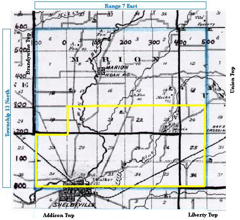
Land Records
Township 13 North of Range 7 East
Map copied from Illustrated Historical Atlas of the State of Indiana, Baskin, Forster & Co, Chicago, 1876
The black lines mark the present day townships Marion, Union (secs 1, 12, 13, 24, 25, 36) and Addison (secs 26-35. The bottom blue line represents Range Road (00); the top would be 600N. The left blue line represents County Road 100W; the right would be 500E. Marion and Union Twps are to the top/north; Union Twp is to the east; Liberty and Addison Twps are below/south; Addison and Brandywine Twps are to the west.
Original purchases from the United States Government
| 6 Baker Alexander Hubble Wright Kaster Rhodes | 5 Whited Fox Kaster Whited Davis | 4 Laycock Fox Greer Sleeth Sleeth | 3 Sleeth Fox McCombs Camblin Fox Bollibaugh Sleeth Fox | 2 Sleeth Parker Allen Alexander Sleeth Copple Burch Fouts | 1
Snow Fouts Greenberry Stoddard Talbert Burtch Copple Creek 7 Bedinger Stuck | VanVoast Foster Glancy VanVost Vernon VanVoast 8 Vernon McCormick | Welliver Cummins VanVoast Hodges Kinsley Vernon 9 Williams Fisher | Foutz Wilson Fisher Higgins 10 Fox Roads | Rhoads Foreman Rhodes Roads 11 Smith Copple | Rhoades Cook Rhodes Foreman Bates 12 Cotton Smith | Golding Brown Vail Phares Smith Brown Cotton 18 Shiples Glancy | VanVoast Bassett VanVoast Conwell Rice Major Tustin 17 Brown Wallace | Green Bassett Crane Heath 16 | School Commission Lands 15 Hodges Benefiel | Gatewood Davis Smith Rhodes Colglazier Copple 14 Smith Cox | Cornelius Caulkenbaugh Hauk Donnell 13
Hawk Scott | Golding Brown Donnell Klum Rice Rice 19 Curry Jones | Hawkins Robinson McCoy Pell Hall Kinsley Henry Steel 20 Wilson Hinds | Crane Calvert Walker Montgomery Smith 21 Walker Walker | Walker Gordon Sleeth Smith Hinds Robins Postell 22
Walder Coates | Ungeron Strasinger Lortz Dovennbit Postell Higbee Yarling 23 Cornelius | Gatewood VanScoyoc Gatewood Morris 24 Cotton Bates | Gunning Gatewood Glenn Brooks 30
Kinsley Church | Applegate Campbell Mayhew Gearhart Lefever Henry Walker 29 Hinds Bass | Walker Walker Kinsley Walker 28 Walker Lyon | Walker Cornelius Porter Knepper 27 Cornelius Nave | Burkhart Williams Kent Sherry Heifner Nave Gatewood Robertson 26 Morris Cornelius | Bivans Williams Gatewood Rice 25 Glen Vail | Gordon Barnes Robison Bush Wheeler 31 Campbell Walker | Davidson Sherer Sherer 32
Walker Kinsley | Barricklow Love Wilson Powell Goodrich Walker 33 Carnell Powell | Walker Wilson Porter Crane Barricklow Higbee Young 34
Walker Powell | Vanbuskirk Higby Coats Campbell Donnell 35 Coats Higby | Robertson Robertson Wheeler Allen Donnell 36 Fouts Snow | Greenberry Stoddard Wheeler Talbert Copple Burtch Talbert |
The above table is for a general overview of the neighborhood. For an exact description of the location and amount of land owned by each individual, please click on the individual section number (1-36) in the above table.
Adjoining lands:
North, T14N R7E
East, T13N R8E
South, T12N R7E
West, T13N R6E
 Land Records Index
Main Page
Land Records Index
Main Page